
Depending on where you are in the valley, things can be sunny and dry, or shady and wet.
This Monday, April 6, there will be a trail meeting in the Minnie Moore Room at the Hailey Community Campus from 5:30 to 6:30 p.m. It will provide area land managers with a chance to describe plans for post-fire trail restorations, and to hear from trail users about issues they would like to discuss. The meeting is being hosted by the 5B Restoration Coalition. The 5BRC is a group of area agencies, organizations, businesses, and individuals committed to bringing the community together to protect and restore our lands and natural assets from wildfires.
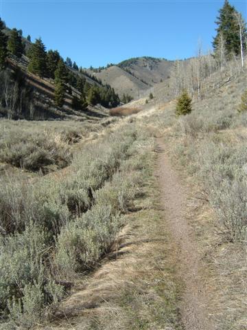
Oregon Gulch Trail is open for about 2 miles for out-and-back trips.
This week’s somewhat mild weather and sunny skies have allowed a few more trail segments to become dry enough to open. There are not many loop opportunities, or even entire trails open, but we are working to keep an eye on conditions and to open portions of trails as they become ready for traffic. In our observations and monitoring of conditions it has been gratifying to see a high level of compliance with the closures that are in place. Our community has a good understanding of the importance of staying off of wet trails, and it shows in the field. Thank you for your patience and good trail practices.
Here are a few updates regarding area trail and road conditions, openings and closures:
- Oregon Gulch Trail #183 is partially open. It is dry and ready for traffic for 2 miles. Use it for out-and-back trips only.
- Fox Creek Trail #149 is partially open, but only from the BLM Lake Creek Trailhead side, and only in the low, open meadows. The trail is open from the Lake Creek Trailhead to the exercise station which is located about a mile north of the trailhead. Do not use any other portions of the Fox Creek Trail. If you are driving to the trail, please park at the Lake Creek Trailhead.
- Corral Creek Trail #325 is partially open, but only for about 1.3 miles. You can travel on the trail from its western end near the Trail Creek Trailhead to the trail’s junction at the Trail Creek Road and Corral Creek Road intersection. You can turn around and head back the way you came here, or head back toward the trailhead on Trail Creek Road, then connecting to the Trail Creek Trail #305 to link back to the trailhead. The portion of the Corral Creek Trail that parallels Corral Creek Road is closed due to muddy conditions.

Most of the Old Adams Gulch Road Trail #146 is closed.
- In Adams Gulch there are a number of short out-and-back routes open, and one short loop opportunity available for your recreation pleasure. From the Adams Gulch Trailhead the Adams-Lake Creek Connector Trail #321 is open for about 1.2 miles as an out-and-back. Sunnyside-Lane’s Trail #316 is open. The lowest reaches of the Pork Chop section of the Adams Rib Trail #142 is open for about 1/2 mile. The trail is signed closed just below the pond. Citizens Trail #143 is partially open from the Lane’s Trail side. It is open for about 1 mile as an out-and-back. Please turn around at the snow. Most of the Old Adams Gulch Road Trail #146 is closed, but a short stretch is open below Lane’s Trail. This open section of the road/trail can only be accessed from the Sunnyside-Lane’s Trail. It is open above the 1-mile mark (near the second bridge) to the junction with the west end of Lane’s Trail. The Old Adams Gulch Road Trail #146 is closed above its intersection with Lane’s Trail.
- The Greenhorn Trailhead is open. Cow Creek Trail #180 is partially open. It is open from the trailhead to the Cow Creek Short Cut Trail #930. Above this, the Cow Creek Trail #180 is open, but only for a short ways beyond its intersection with the Cow Creek Short Cut Trail. Please turn around where conditions get wet. The Cow Creek Short Cut Trail #930 is open. The Mahoney Ridge Trail #153 is partially open; for 2 miles as and out-and-back. The Cowhorn Trail is open. The Mahoney Trail #821 is partially open; as and out-and-back for 2.1 miles. Please note that at this time the Mahoney Trail #821 can only be accessed by way of the Mahoney Ridge Trail #153, and the Cowhorn Trail. This is because the Greenhorn Trail #156 is temporarily closed due to wet conditions. (Please note that due to changes in the FS trail inventory the Mahoney Trail #821 is temporarily signed in the field as Greenhorn-Mahoney Trail #156. A new replacement sign will bear the correct trail name and number of Mahoney Trail #821.)

Springtime view.
Remember: Please obey all closed signs. Turn back on trails that are muddy but which are not yet signed as closed. Stay in the center of the trail when passing through very short patches of ice or mud. THANK YOU!
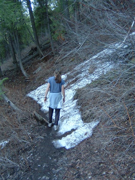
On open trails, where you encounter short stretches of snow or mud, try to stay in the center of the trail to help reduce trail widening.
The above listing does not describe all of the open sections of trails and roads in the valley, but these are some of the most recent openings. For additional photographs and more information check out the latest Ketchum Ranger District Trail Report: April 2, 2015 KRD Trail and Road Report
For trail updates, information and maps visit the BCRD Summer Trailink site at: summertrailink.bcrd.org, or simply, trails.bcrd.org